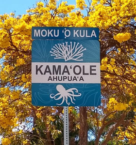
Kama’ole ahupua’a sign on South Kihei Road. Photo by P. Fiene.
Have you seen the beautiful new ahupua‘a signs appearing along South Maui roadways (South Kihei Road, Pi‘ilani Hwy and Mokulele Hwy) during the last six months? These are not the plain state or county signs telling drivers to do this/don’t do that, but handsome signs in rich colors with Hawaiian words and pictures of plants and animals from the land and sea.
Once you understand what these signs mean, it feels like you’re in on a secret. The “secret” of knowing in which part of Maui you are living according to traditional Hawaiian land divisions.
Land Division on Maui
Maui is divided into twelve moku (districts). Most moku begin high up on the mountain and extend to the sea.
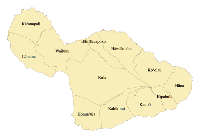
The twelve traditional land divisions (moku) on Maui. (From Wikimedia Commons, the free media repository)
Within each moku are long narrow segments called ahupua‘a. Most, but not all, of these ahupua‘a stretch from the uka (upland) to the kai (sea). Ahupua‘a boundaries are usually designated by mountain ridges, streams or gulches. Ahupua‘a is derived from the word “ahu” meaning stone altar or stone pile, and “pua‘a” meaning pig. The boundary markers for ahupua‘a were traditionally piles of stones on which was set a carved wooden image of a pig head. Here offerings would be left to the agricultural god Lono and to a high chief who was the god’s representative.
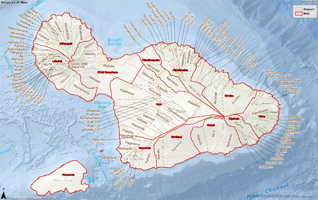
Map showing Maui ahupua‘a land divisions. From DLNR Hawaii website: https://dlnr.hawaii.gov/shpd/files/2015/06/Ahupuaa_Maui.pdf
This method of dividing the land was practical for a self-sustaining culture. No barges or airplanes brought food, clothing, building materials, craft supplies, sporting equipment, etc. That meant that the people had to obtain and cultivate everything by their own labor. To provide all these necessary resources, most ahupua‘a included part of the coastline and the sea, a lowland area for agriculture, and an upland forest area.
After Western contact many ahupua‘a names were combined under a single name. Kihei for example encompasses six ahupua‘a! Fortunately, many of the beach parks and parks around Maui carry the names of these ahupua‘a land divisions. We are therefore familiar with some of the traditional names such as Kama‘ole, Waiohuli and Keokea. Many people do not realize that these beach park names are not random but carry names that originated deep in the past.
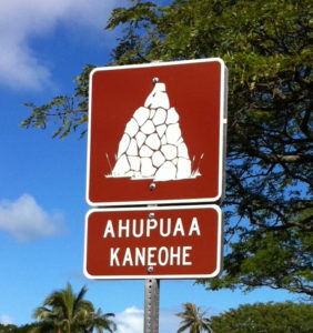
An ahupua‘a sign on Oahu
The New Ahupua‘a Signs
The ahupuaʻa/moku sign project idea was introduced by Council Member Kelly King to the Kihei Community Association and ʻAha Moku ʻO Kula Kai Council in Feb.-Mar. of 2017. Vernon Kalanikau, Representative of AMOKKC, took the initiative as Director of the project to create, design, do research and development, and coordinate group discussion and outreach.
A year into the project, Wailuku resident, then-12-year-old Riley Regan, wrote a letter to The Maui News. He wrote that he had seen ahupua‘a signs on Oahu. He had recognized them because he had learned about ahupua‘a in his 7th grade history class. Riley asked if anyone would like to help him in getting similar signs erected on Maui. ʻAha Moku Representative for Kula Kai, Vernon Kalanikau, contacted Riley to join in the project.
Kalanikau, who is the overall project coordinator, brought together a small group who worked on the design of the signs. They decided what colors and iconic images should be used. They gathered knowledge from as many people as they could – people who had local knowledge or remembered stories from their areas.
Each sign has the name of the moku on top and the name of the ahupua‘a below. The graphics show the food or other resources gathered from the wetlands, land or sea within the ahupua‘a. Eventually, Kalanikau says, there will be a website showing all the signs and identifying the icons. He says it will also include the mo‘olelo (story or history) of the ahupua‘a.
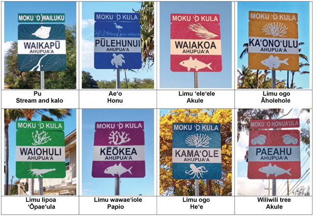
South Maui ahupua‘a signs. Left to right in both rows are north to south. Photos by P. Fiene.
The first sign was installed in October 2018, at Kenolio Park on the edge of Pūlehunui ahupua‘a in the moku of Kula. More signs were then added along South Kihei Road. And in April the last signs in South Maui were placed on Pi‘ilani Highway. This completed the Kula moku except for a couple signs awaiting completion of construction projects.
Eventually, each moku will have to repeat the steps Mr. Kalanikau did for Kula Kai. This is exciting! Place names often reflect the intimate knowledge Hawaiians have of the weather, animals, plants, land features, historical events, beloved ancestors, and legends of their gods. When Westerners re-named land features in the islands, roughly 1500 years of context and meaning were temporarily hidden from public view.
For example, the tuff cone on Oahu popularly known as Diamond Head was given this name by sailors who thought that the calcite crystals on the slopes of the cone resembled diamonds – which are not found in Hawaii. In comparison, the Hawaiian name for the highest peak of the cone is Le‘ahi, which was given for the volcanic peak’s resemblance to the dorsal fin of an ahi (yellowfin tuna) – which are found in Hawaii. Place names that are based on ancestral knowledge become a significant part of the culture. They add meaning and a sense of connection to the land where we live.
Erecting these signs and displaying these place names acknowledges and preserves Hawaiian knowledge of these places. To me, seeing these signs and the knowledge they bring, adds depth and richness to life on Maui. Knowing that Kula doesn’t just refer to the town upcountry, but to the entire wedge-shape section of land, reminds me that this method of land division was practical and necessary for meeting the needs of people who lived so long ago. And on an emotional level, when I pass the sign and enter the Kama‘ole ahupua‘a I relax and think to myself, I’m almost home.
Written by Pauline Fiene. Photos as credited. Sincere thanks to Vernon Kalanikau for identifying the animals and plants on the signs for me, for taking the time to answer questions about the project and for proofreading the article. Thanks also to Rob Nelson for sign hunting :-).
***************
http://www.mauinews.com/opinion/letters-to-the-editor/2018/06/ahupuaa-signs-could-show-maui-ancient-land-divisions/
http://www.mauinews.com/news/local-news/2018/11/sign-project-aims-to-raise-awareness-of-the-states-ancient-land-divisions/
http://hbs.bishopmuseum.org/pubs-online/strm/04-Mueller-Domboisr.pdf
Comments 8
Thank you for writing this Pauline! Excellent job explaining the meaning of these lovely signs. I used to bring an Ahupuaa map of Maui to outreach events and teach folks to find out which one they live in. Mahalo
I was back in January and they weren’t there before, lovely backstory, and a great reminder of the culture.
Mystery solved, too!
Mahalo!
Exceptional story, Pauline. I always appreciate your “deep-dive” 😉 articles and stories on all things Maui.
Brian and I were back this January and we jogged past the Kama’ole ahupua‘a each day and it was new and so mysterious! Mystery solved and then some.
Mahalo Pauline for sharing this sign project to our communities and visitors.
Vernon Kalanikau – Creator and Director of Kula Kai Sign Project.
Is there a place to buy the signs and part of the money goes towards more awareness or additional postings?
Author
Hi Erin. Not at this time.
Pingback: New Signs Show Original Maui Place Names – Planet Maui Ø – Maui Awaits
Thank you for this explanation. We noticed them immediately upon visiting and it became almost a game to find as many as we could. Loved learning about this.